Monday, December 14, 2015

They won't let their beloved neighborhood become another Wicker Park,

A recent article about anti-gentrification forces in Pilsen contained the this statement.

As a Wicker Parker, I freely admit that we chose the path of gentrification, but I am tired of being the poster child for a narrative about people being displaced by Yuppies and Hipsters.

This narrative is usually accompanied by a graph like this.


It seem to show that Hispanics, after being displaced from Lincoln Park in the 60s, migrated to Wicker Park. Which grew to a predominantly Latino neighborhood, only to have them displaced again by Yuppies in the 90s.


Technically it is true (except for the part about growing) but it doesn't tell the whole story.

I have spent a lot of time pouring over census records of the 8 tracts that make up Wicker Park and here's a chart of its Hispanic population count.


You'll notice that the numbers jump in 1970 and have declined ever since.
There is no precipitous drop in the 90s. In fact the decline is so close to a straight line that no evidence of any period of displacement can be found.

Back then, Wicker Park was a slum. It was that way already in the 1960s and it was apparent to the incoming Hispanic population. No sooner did they get here, than they started to leave.

Here's a chart comparing the change in each group's populations between each census.


The period of Hispanic dominance of the population came not from the growth of that group, they were actually declining in numbers. Instead it came from the fact that everyone else was leaving faster.

That ratio switched in the 1980s.

Paul K. Dickman

Tuesday, September 8, 2015

Make no little plans 6, Unintended consequences


Two flats

A curious thing about the 1957 zoning code is that it pretty much made it impossible to build a two flat on a standard city lot. I have always wondered about it. I’ve never heard anyone complain about them. The previous code had duplex districts where such things were a matter of right. The 57 map  replaced them with R3 districts. But the text precluded putting a two dwelling structure on one lot in those districts.

The standard city lot is 25x 125 to 25x150 or 3125 to 3500 square feet.

The Code controlled density by limiting the number of dwelling units by the square footage of the lot.

In the case of R3 it was 2200 sq ft of lot area per dwelling unit. As you can see, in order to build a two flat you would have to combine two standard lots. Why would you bother? Why not just build two single family homes?

The new code also defined the minimum lot size for each district. I have always wondered about this as well, I mean the city was 95% subdivided by 1957. Why would anyone think it was an issue?

As I researched these articles, I could find no enmity to this humble dwelling. In fact I found quite the opposite. The Master plan of residential land use of Chicago clearly stated that they expected 25%-35% of the city’s population to reside in “Two family dwellings”.

Why were these excluded from the 1957 code? Was this just some typo that followed us to this day?

Then I read “Building new Neighborhoods; subdivision design and standards, 1943”.

And it became clear. 
They intended to change the size of the standard city lot. 
Actually, they hoped to re-plat the bulk of the city
In their opinion 25 ft lots were too narrow, 35 ft was marginal, 40-50 ft was preferred.

A 35x150 lot has 5250 sqft more than enough for two dwellings.

“How’s that supposed to work.? Wouldn’t a 35ft lot line be in the middle of someone else’s house?” you might ask.

Not if you tear them all down.

They write:
“REDEVELOPMENT OF OLD CHICAGO
The recommendations contained herein pertaining to subdivision design and standards would apply not only to the land now vacant but to the redevelopment of the 23 square miles of blighted and near-blighted properties which must be rebuilt within the next generation. Thus more than 41 square miles of land in the city would benefit from improved standards of design and from practical specifications for residential land improvements. Within these 41 square miles over 300,000 families could find new home sites located in well-designed, attractive neighborhoods of good character and environment.”

Still, that’s only 20% of the city.

In the Master Plan they defined the areas of the city as:

14.60% Blighted & Near blighted
36.31% Conservation
23.34% Stable
the remainder was either vacant or under going some kind of development

You can see them in this map.

Notice that the only areas they have marked as “Stable” are out in the “Bungalow Belt” where the lots are already wide.

They figured that by the time they dealt with the blight, the “Conservation” areas would now be blighted, either through decay or by contrast with the “Rebuilt” areas. And then they would redevelop those.


Here’s another map of future development areas.

Notice that the areas formerly tagged as “Conservation” are now labeled “Ripe for rebuilding”

And the former “Stable” areas, now they’re tagged as “Conservation”.


Since the future solvency and livability of our great cities depend upon removing the cancerous blighted areas that are sapping their vitality and upon building new model communities on the cleared sites, every device, legal and financial, should be employed to make it economically feasible for the blighted areas to be rebuilt by private enterprise.


The scope of this is staggering. They fully intended that the normal process of future development, would involve taking property through eminent domain, clearing it at government expense and redistributing it to some connected developer who build only what the Plan Commission liked.

Luckily, this did not come to pass, but as casualty of battle, the two flat was lost.
It needn’t be permanent though. You need only change one character of the current zoning code to make these “as of right” in RS3 districts.
Change the Minimum Lot Area per Unit Standard for RS3 from 2500 to 1500.

This would double the population density potential of about half the city and hopefully spur development out in the neighborhoods where it’s needed.

These maps are courtesy of the Hathitrust Digital library, they were digitized by Google from originals in the 
University of Michigan collection

Sunday, September 6, 2015

Make no little plans 5, We don't want nobody nobody sent


Wicker Park’s first renewal project would also be part of its last, although the two would be separated by almost 30 years. In ‘55 and ‘56 they demolished a couple of dozen homes on Mautene and Bauwans (two streets now almost completely lost to history) to make way for some parking lots where they planned to put the new shopping center.


This was noticed by some in the community and in’56 the East Humboldt Park Planning and Conservation Commission was formed with the intent of getting the area designated as a “Conservation District” The Illinois Urban Community Conservation Act of 1953 and it’s clone, the Federal Housing Act of 1954 created these districts to allow urban renewal in areas not yet classified as slums. It freed up federal money for land acquisition as well as for repairs to existing structures. For the city however, it would have one fatal flaw, it required community input.

The East Humboldt commission was headed by Valentine Janicki, a local business leader, owner of the United Novelty Mfg Co. and future president of the Polish Alma Mater Association. He was not without his own agenda. He had his eye on 9 sq blocks of land his commission felt need to be cleared. He also had political aspirations, after this he would parlay his Polish and political connections into a seat on the sanitary district, where like all good Chicago politicos he would eventually be jailed in a sludge hauling kickback scheme.

In ’57 Mayor Richard J. Daley, conscious of the Polish vote appointed him to the Community Conservation Board, the group that selected which parts of the city would become conservation areas and in ’58 East Humboldt Park, an area bounded by Grand, Fullerton, California, and the river (later the expressway) would gain that distinction.

Without Janicki at the helm, the East Humboldt commission drifted into obscurity. This was probably a good thing. The Community Conservation Act was literally designed to be co-opted by private enterprise. It was created to allow the University of Chicago turn Hyde Park into their personal compound and later was used by the Southtown Planning Association in their goal of stemming black migration in Englewood.

The city started making a conservation plan but was playing it close to the vest. Its next two clearance projects were several houses on Damen for rebuilding the Wicker Park School (now Pritzker) in 1960,

And a large parcel just to the north of this for the CHA elderly high rise project at Damen and Schiller in 62 -63


These, and announcement of several clearance projects, including the one in what we now call Noble Square, would be a wake up call. Several church leaders, fearing the dispersal of their flock in 1962 formed the Northwest Community Organization (NCO), a supergroup of smaller community organizations and a member of Saul Alinsky’s Industrial Areas Foundation. The local community group at the time, The Wicker Park Neighborhood Council aligned themselves with the NCO.

The NCO managed to get several sympathetic people appointed to the  East Humboldt Park/Near Northwest conservation area’s Conservation Community Council (CCC),  a Mayorally selected body of local citizens with oversight and veto power over the plans and recommendations of the Dept of Urban Renewal for each conservation area. Together they would battle the city to a halt at every turn.

In ’67 they battled the plans for the Tuley High (now DeDiego) expansion. Although they wanted its expansion, the Board of Ed and the DUR wanted it to go east across Clairmont to Oakley in the land they preemptively downzoned for a park. The NCO felt the properties to the west were in much worse condition and better candidates for demolition.

In ’68 the NCO would convince the Board of Ed to build a new high school inside Humboldt Park, but that would backfire. They would have to swap land to the park department. You guessed it, the land they wanted to swap was the same blocks, Oakley to Leavitt, Potomac to Hirsch they had downzoned. So the NCO fought that too. In the end the city built Clemente on the site of an old street car barn.
 
In ’69 the city produced its conservation plan for the area, a vague document with large areas slated for demolition and the NCO went apesh!t. They wrote their own plan. the “People’s Plan” It called for only spot removal of dilapidated buildings, no new construction over 3 stories and, the dealbreaker, 90% of all new construction to be affordable housing.
Through their seats on the CCC they vetoed any plan that didn’t conform to theirs.
Daley, tired of this stalemate, tried to break their power by appointing five of his own people to the CCC in place of theirs, and the NCO took him to court. They won and the city pretty much threw up its hands. 1973’s Chicago 21 plan did not include anything west of Ashland.

Despite this victory NCO would play a roll in the extensive loss of Wicker Park’s housing. Between 1970 and 1980 we would lose 22% of all our housing units. But few would be at the hands of the city, most were due to arson.

Two initiatives combined in ways no one could foresee.
The NCO used the Department of Buildings to put a lot of pressure on absentee landlords, calling in inspections constantly, in some cases forcing demolition but mostly to force landlords to repair them.
Most of Wicker Park was redlined by the banks until the early 80s, mortgages and home improvement loans were simply unavailable. But what most people don’t realize is that we were redlined by insurance companies as well.

The NCO struggled to end the redlining. They had succeeded to get the FHA to back some mortgages, but the FHA was only interested in single family properties. They also lobbied for a high risk insurance pool. After the King riots, they got their wish. The Fair Plan Insurance Act made it possible for anyone to get affordable fire insurance.

Faced with a low rent property, more valuable as a vacant lot, with the city saying, repair it or they would condemn and take it, the availability of fire insurance led to the biggest epidemic of landlord lightning in the city’s history.

Evergreen between Leavitt and Hoyne lost 2/3 of its buildings and looked like a war zone.

Although the pressure from the DUR was off, Wicker Park was still in trouble.
Housing losses continued. Between 1970 and 1980 we lost 35% of our population and the neighborhood became a house divided. Gang struggles, ethnic tensions, all played a role, but for our story the biggest divide was between those who thought that rising property values were a bad thing and those who thought it was good.

Those people, labeled gentrifiers (probably rightly) had an idea, landmarking. It could stem the housing loss and get federal grants (in the early years) for repairs. They formed the Old Wicker Park Committee to lobby for this designation.  In 1979 they succeeded in getting it much of it designated a National Historic Landmark District and set about to actively promote the neighborhood.

But battle lines were drawn in the neighborhood, one group protested affordable housing developments, one protested market rate housing developments. One took realtors to court for putting up “For Sale” signs, the other sued over design issues of affordable housing projects. Neither group could see the goals they had in common and neither could claim this as their finest hour.

The city still had some plans up their sleeve. Determined to get one of their plans realized, in September of 1977, Richard W. Albrecht, the city's deputy project planning coordinator, and Robert Littlebridge, director of economic planning for the city's department of planning, under Bilandic, visited Sievert Electric company on Ashland and told them not to go ahead with any expansion because the city had an interest in the area.

In October of ’79 the next mayor, Jane Byrne, announced their plan for the “West Town Shopping Center”. At first it seemed to only involve the vacant Weiboldt’s building, but less than a month later it became clear that the project involved the clearance of nearly 60 buildings.
 
The first developer for the project backed out when $7 million in federal loan guarantees were denied. Perhaps it was just Reagan era austerity, but a Jan 20, 1981 memo from the U.S. Dept of Commerce said “The projected retail sales from the applicant’s project would overwhelmingly come from the current business of existing competitors. This project will have an adverse impact on existing retail and office space sales”

But this didn’t stop the project. Joseph Freed stepped in and took it over.

At the cost of approx $.25 million in 1955 dollars for the parking lots and $3.73 million in 1980s community block grant dollars, the city acquired and cleared the land and sold it to Freed for $635,000. Then they got him property tax incentives worth an additional $4.9 million.

The NCO would wage a valiant effort but they would lose. It would be their last hurrah. They continued on fighting smaller fights until 1993, when the would close up shop. Although their financial arm, the Bickerdike Redevelopment Corp would continue to this day.

The U.S Dept of Commerce’s memo would be prophetic. Unless you include the time when it was filled with government offices, I don’t think the shopping center ever replaced the 275 jobs it displaced and I doubt that it ever paid as much in taxes as the businesses and residents on the 120 parcels it contained would have. While the rest of Wicker Park’s shopping areas blossomed, the south end of Milwaukee Ave languished.

In the end, the gentrifiers would prove to be right. The housing losses declined through the 80s and turned positive in the next decade at a rate nearly 20 times the city average. We have put back all the housing we had in 1970 and after 25 straight years of population growth (25% since 1990 vs City pop -2%) we’ve put back all the people we had in 1980.

According to the 2013 estimates, the current population density is around 25,000 ppm.
If our household size matched the city average, we’d be in the mid 30s, right where they wanted us at the start.


Sunday, August 23, 2015

Make no little plans 4, If at first you don't succeed, try, try, try again


Land use

Their plans for land use were as subject to change as all the others.
In general, they believed that residential uses should be separated from any other. Industrial uses should be consolidated and separated from dwellings by a buffer zone.
Business use would be better served by the new shopping centers. Mixed uses (commercial with apts) were wasteful. They created low rent apartments and only fed what they felt was an over supply of commercial space.

The 1947 zoning map shows what was allowed at the start.


The ’42 Master plan shows what they wanted for residential uses.

Over all, they reduced the size of the residential buildings, but planned to make up for it by increasing the amount of land available, by reducing commercial and industrial uses and through more efficient distribution of the land.

But they wanted to lessen crowding and intended to build an area for a population density of about 30-35,000 people per sq mile (a reduction from our 1940 density of 43,000).

The ’48 comprehensive plan is more specific. It has defined the shopping areas, new parks, and buffer zones, but is has increased the land for industry at the cost of high density residential along Milwaukee.

In 1957 they completed drafting a new zoning ordinance and completely re-drew the map.


You can see some of their intentions. They preemptively downzoned the area for the park between  Oakley and Leavitt. They removed most of the commercial property on Damen south of North, and pretty much matched the Comprehensive Plan’s industrial lay out with a little extra added in down by the Felt & Tarrant Adding Machine plant.

The notion of wide scale land clearance and redistribution had become less realistic after the Urban Community Conservation Act of 1953 and their plans gradually got smaller.

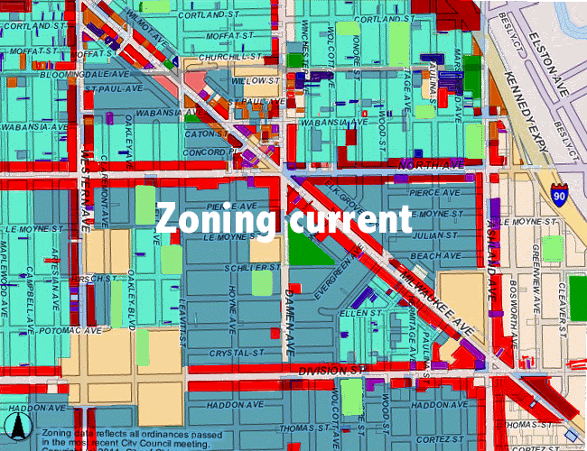
I apologize for my efforts on the current zoning map. Decades of spot zoning have left it looking like a painter’s drop cloth. There are so many, that I gave up East of Ashland.

Paul K. Dickman


Sunday, August 9, 2015

Make no little plans 3, If at first you don't succeed, try, try...


Streets

It is important to realize that all the things we consider as the very model of a modern urbanist plan, things like increased transit infrastructure, increased density near transit stations and employment centers and walkable neighborhoods, were the cornerstones of these earlier plans as well.

The difference was that they wanted to reinvent the neighborhood.

To the plan commission, each neighborhood was an area bounded by four major (1/2 mile) streets. Each neighborhood would have sufficient grade schools for its intended population located on the interior with a park connecting them and perhaps a neighborhood shopping center (strip mall) on the edge.

Several neighborhoods would form a community area. Each community area would contain sufficient high schools and a large community shopping center at their junction.

Several communities would be bounded by the new expressways. Ours included not just the Kennedy, but ones on California and Grand Aves as well.

In the neighborhoods, through traffic was the nemesis of walkability. They planned to widen the major streets to provide traffic capacity, and interrupt the flow through the side streets with cul-de-sacs and loops. They also felt that alleys were a waste of land and, that  the rights of way of the side streets could be reduced from a typical 66 feet down to 50 feet.

This is what they saw a model for the new neighborhood. This one was an example they found in Columbus, Ohio.

Using this as a model this is what Wicker Park could look like.


The parks and shopping centers are taken from the actual plans, but more on land use in a later segment.

Their plan for the major streets varied widely.  In ‘42s plan for residential land and ‘48s preliminary comprehensive plan they were not specific, although it is a safe bet that they hoped to widen North Avenue to match the portion west of Western. But in 1952. their plan for the northwest central area, went out on a limb.

They wanted North ave (currently 100’ west of Western, 66’ east) widened to 200 feet (incorporating the Humboldt Park Elevated ROW). Milwaukee should be widened to 250 feet (currently 66’) at least as far south as Grand. And they felt that it would be cheaper to acquire the necessary land on streets like Damen and Racine than on Western and Ashland, so Damen, Racine, Chicago and Armitage should be widened to 200 feet.

The extra width of North and Milwaukee was to provide space to bury the rest of the Elevated lines. It was cheaper to put them in a trench and that was their plan.

By 1958, they softened somewhat. A few things had happened. For one the Humboldt Park El line closed about the time of their last plan. Another thing that happened is that the area fought for and succeeded in getting the “East Humboldt” area classified as a conservation area. This curtailed widespread land clearance and increased certain forms of federal funding for building improvement and FHA mortgages.

In a preliminary traffic study CDoT greatly reduced their road widening goals.

Milwaukee was to remain at 66’, North, Chicago and Damen widened to 100’ and Armitage widened to 80. They also seem to have given up on the Grand Ave Expressway, it was now recommended to be widened to 100’.


Milwaukee, however was not immune from further planning. In 1968 they wanted to deemphasize the diagonal streets. They presented three possibilities for Milwaukee between North and Division. All of them involved closing it to through traffic. One was to tear out all the commercial and make it a residential street, another to keep it a commercial strip, with residential infill replacing the deteriorated structures, and finally to tear out everything, build shopping malls at either end and turn the rest into a park.

The thing that surprised me the most, while researching these plans, was the disdain the urban renewal planners held for the street grid. They seemed to be of the opinion that the middle class was being driven from the city by the unrelenting monotony of parallel streets.

Paul K, Dickman


http://wickerblather.blogspot.com/2015/09/make-no-small-plans-5-we-dont-want.html
http://wickerblather.blogspot.com/2015/08/make-no-little-plans-4-if-at-first-you.html

http://wickerblather.blogspot.com/2015/08/make-no-little-plans-2-if-at-first-you.html
http://wickerblather.blogspot.com/2015/07/make-no-little-plans.html

Saturday, August 1, 2015

Make no little plans 2, If at first you don't succeed....


Blight

Alas, the tiny hamlet of Wicker Park could not avoid the planners. The city drew up a plan for us, In fact they drew up at least five official ones. An assortment of private parties drew up their own. Some, were written as a rebuttal to the Plan commission’s ideas, others came from well meaning busybodies and graduate students.

A 1939 WPA sponsored survey of housing had noticed us and its report led the city planners to label us as “Nearly blighted” in the 1942 “Master plan of residential land use”
Below is their assessment of the conditions.


Their assessment probably wasn’t far from the truth. We hadn’t been a fashionable neighborhood since the teens the housing stock was old and run down and packed chock full of people. But this war time, and although refining their plan, the city didn’t go any further.

In 1952 they drew up  "A plan to guide redevelopment in the northwest central area of Chicago" and once again they assessed our blight.

 
Add caption

You can see, the map has changed some. They separated the industrial areas (this plan had provisions for industry), the blight has moved around some, and the conservation area is much smaller. They claim the source of the data is the same 1939 survey, so I am not sure how the blight could wax and wane. Perhaps blight is in the eye of the beholder.

The city had more urgent blight to fry in Lincoln Park and Noble Sq, so it wasn’t until the late 60s that they thought about sending the dozers our way.

In 1969 they drew the “Proposed treatment areas for the East Humboldt Park, Near Northwest Area”, and once again tiny Wicker Park was on the map.


In the end, little of their plans would be built and large scale demolition would be held to a few city blocks.


Next time I’ll discuss the multiple plans for Wicker Park’s streets.


Sunday, July 26, 2015

Make no little plans


In the 1950 census, Chicago hit its peak population 3.6 million. Few realize that this last spurt of growth was due entirely to the great migration. The African American population increased 220,000 while the white population actually declined by about 3000. 

Ok, 3000 doesn’t seem like much, but when you factor in the rate of natural increase (birth rate – death rate) it constitutes a loss of 750,000 potential Chicagoans.

The first thought is to put this loss down to “white flight”, but that doesn’t hold water.


 Here’s a map. It shows areas of population loss and gain between 1940 and 1950. 
The red portions show the African American communities traced from a 1950 settlement map showing Chicago’s various ethnic communities.


Vast losses occurred in tracts where the residents never saw a black man.


The areas of loss have more in common with this map, showing areas of blight.


 Or this one indicating areas of high population density.


The city had been bleeding population to the suburbs for decades. The city of 1950 was a dump. The free market had favored the slumlord since the depression and our neighborhoods were dirty, crowded, smelly, run down places. As soon as the streetcars crossed the city limits, people loaded up their families and moved.

This didn’t escape the notice of the people who drew those maps. They are from the Chicago Plan Commission’s 1942 Master plan for residential land use.

Their plan was to bulldoze the blighted and near blighted areas, and create mini suburbs between the half mile streets, each with its own school and park. The side streets would be cul-de-sacs and the 1/2 miles widened to carry all the traffic. Then, they’d plop shopping centers at the corners.

Here’s their plan for Little Italy.


They write:
WEST SIDE REDEVELOPMENT PLAN. It is possible to create new neighborhoods and better residential patterns near the center of Chicago without scrapping all of the streets and utilities which exist today. This plan for the reconstruction of a West Side Blighted area calls for the demolition of the present obsolete buildings in order to provide much-needed open space for parks around the schools and community centers and ample yards about the residential buildings. Unnecessary streets would be closed to protect the residential sections from traffic hazards, but major through streets of the present would be retained. Heavy traffic would be confined to the super-highways and section-line streets which form the boundaries of this community. Organization of shopping facilities into coordinated centers with parking facilities and access to highways would make them easily available without conflicting with purely residential areas. Residential areas would be built up with apartment buildings three to four-stories in height and with two-story group houses. A moderately high population density would be achieved without crowding of either land or people.

Unencumbered by existing utilities in undeveloped areas, they hope to do away with the grid all together.
Here’s their idea for Scottsdale


They write:
PROPOSED PLAN FOR DEVELOPMENT OF A VACANT AREA IN SOUTHWEST CHICAGO. Here is indicated how an area of now-vacant land comprising over one and one-half square miles on the southwest edge of the city might be subdivided according to the best principles of community design. Curved streets in the interior residential portions discourage dangerous through traffic which is channelized into the bordering super-highways. Schools placed near the centers of the five neighborhoods are so located that small children can reach them without having to cross major traffic arteries. A centrally located high school with an associated athletic field and community park serves the entire community. Adjoining these facilities is a large community shopping center, and smaller neighborhood shopping centers are placed to serve two or more adjoining neighborhoods. The residential areas are separated into sections of apartments, group houses, and single-family dwellings arranged to give each type the maximum advantages of light, air, and open space around the structures. Such a community design illustrates what might be accomplished by creating an integrated community pattern designed to offer the maximum advantages for living.


Apparently the city of the future would look like Elk Grove Village.


Paul K. Dickman
These maps are courtesy of the Hathitrust Digital library, they were digitized by Google from originals in the