Sunday, August 23, 2015

Make no little plans 4, If at first you don't succeed, try, try, try again


Land use

Their plans for land use were as subject to change as all the others.
In general, they believed that residential uses should be separated from any other. Industrial uses should be consolidated and separated from dwellings by a buffer zone.
Business use would be better served by the new shopping centers. Mixed uses (commercial with apts) were wasteful. They created low rent apartments and only fed what they felt was an over supply of commercial space.

The 1947 zoning map shows what was allowed at the start.


The ’42 Master plan shows what they wanted for residential uses.

Over all, they reduced the size of the residential buildings, but planned to make up for it by increasing the amount of land available, by reducing commercial and industrial uses and through more efficient distribution of the land.

But they wanted to lessen crowding and intended to build an area for a population density of about 30-35,000 people per sq mile (a reduction from our 1940 density of 43,000).

The ’48 comprehensive plan is more specific. It has defined the shopping areas, new parks, and buffer zones, but is has increased the land for industry at the cost of high density residential along Milwaukee.

In 1957 they completed drafting a new zoning ordinance and completely re-drew the map.


You can see some of their intentions. They preemptively downzoned the area for the park between  Oakley and Leavitt. They removed most of the commercial property on Damen south of North, and pretty much matched the Comprehensive Plan’s industrial lay out with a little extra added in down by the Felt & Tarrant Adding Machine plant.

The notion of wide scale land clearance and redistribution had become less realistic after the Urban Community Conservation Act of 1953 and their plans gradually got smaller.

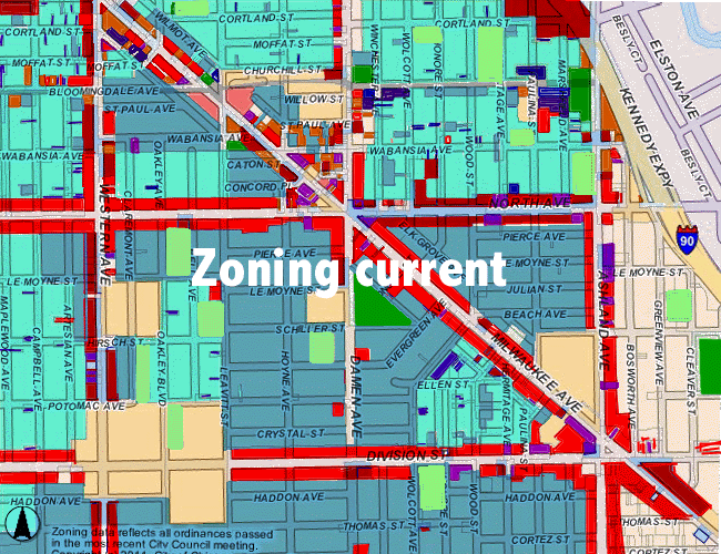
I apologize for my efforts on the current zoning map. Decades of spot zoning have left it looking like a painter’s drop cloth. There are so many, that I gave up East of Ashland.

Paul K. Dickman


Sunday, August 9, 2015

Make no little plans 3, If at first you don't succeed, try, try...


Streets

It is important to realize that all the things we consider as the very model of a modern urbanist plan, things like increased transit infrastructure, increased density near transit stations and employment centers and walkable neighborhoods, were the cornerstones of these earlier plans as well.

The difference was that they wanted to reinvent the neighborhood.

To the plan commission, each neighborhood was an area bounded by four major (1/2 mile) streets. Each neighborhood would have sufficient grade schools for its intended population located on the interior with a park connecting them and perhaps a neighborhood shopping center (strip mall) on the edge.

Several neighborhoods would form a community area. Each community area would contain sufficient high schools and a large community shopping center at their junction.

Several communities would be bounded by the new expressways. Ours included not just the Kennedy, but ones on California and Grand Aves as well.

In the neighborhoods, through traffic was the nemesis of walkability. They planned to widen the major streets to provide traffic capacity, and interrupt the flow through the side streets with cul-de-sacs and loops. They also felt that alleys were a waste of land and, that  the rights of way of the side streets could be reduced from a typical 66 feet down to 50 feet.

This is what they saw a model for the new neighborhood. This one was an example they found in Columbus, Ohio.

Using this as a model this is what Wicker Park could look like.


The parks and shopping centers are taken from the actual plans, but more on land use in a later segment.

Their plan for the major streets varied widely.  In ‘42s plan for residential land and ‘48s preliminary comprehensive plan they were not specific, although it is a safe bet that they hoped to widen North Avenue to match the portion west of Western. But in 1952. their plan for the northwest central area, went out on a limb.

They wanted North ave (currently 100’ west of Western, 66’ east) widened to 200 feet (incorporating the Humboldt Park Elevated ROW). Milwaukee should be widened to 250 feet (currently 66’) at least as far south as Grand. And they felt that it would be cheaper to acquire the necessary land on streets like Damen and Racine than on Western and Ashland, so Damen, Racine, Chicago and Armitage should be widened to 200 feet.

The extra width of North and Milwaukee was to provide space to bury the rest of the Elevated lines. It was cheaper to put them in a trench and that was their plan.

By 1958, they softened somewhat. A few things had happened. For one the Humboldt Park El line closed about the time of their last plan. Another thing that happened is that the area fought for and succeeded in getting the “East Humboldt” area classified as a conservation area. This curtailed widespread land clearance and increased certain forms of federal funding for building improvement and FHA mortgages.

In a preliminary traffic study CDoT greatly reduced their road widening goals.

Milwaukee was to remain at 66’, North, Chicago and Damen widened to 100’ and Armitage widened to 80. They also seem to have given up on the Grand Ave Expressway, it was now recommended to be widened to 100’.


Milwaukee, however was not immune from further planning. In 1968 they wanted to deemphasize the diagonal streets. They presented three possibilities for Milwaukee between North and Division. All of them involved closing it to through traffic. One was to tear out all the commercial and make it a residential street, another to keep it a commercial strip, with residential infill replacing the deteriorated structures, and finally to tear out everything, build shopping malls at either end and turn the rest into a park.

The thing that surprised me the most, while researching these plans, was the disdain the urban renewal planners held for the street grid. They seemed to be of the opinion that the middle class was being driven from the city by the unrelenting monotony of parallel streets.

Paul K, Dickman


http://wickerblather.blogspot.com/2015/09/make-no-small-plans-5-we-dont-want.html
http://wickerblather.blogspot.com/2015/08/make-no-little-plans-4-if-at-first-you.html

http://wickerblather.blogspot.com/2015/08/make-no-little-plans-2-if-at-first-you.html
http://wickerblather.blogspot.com/2015/07/make-no-little-plans.html

Saturday, August 1, 2015

Make no little plans 2, If at first you don't succeed....


Blight

Alas, the tiny hamlet of Wicker Park could not avoid the planners. The city drew up a plan for us, In fact they drew up at least five official ones. An assortment of private parties drew up their own. Some, were written as a rebuttal to the Plan commission’s ideas, others came from well meaning busybodies and graduate students.

A 1939 WPA sponsored survey of housing had noticed us and its report led the city planners to label us as “Nearly blighted” in the 1942 “Master plan of residential land use”
Below is their assessment of the conditions.


Their assessment probably wasn’t far from the truth. We hadn’t been a fashionable neighborhood since the teens the housing stock was old and run down and packed chock full of people. But this war time, and although refining their plan, the city didn’t go any further.

In 1952 they drew up  "A plan to guide redevelopment in the northwest central area of Chicago" and once again they assessed our blight.

 
Add caption

You can see, the map has changed some. They separated the industrial areas (this plan had provisions for industry), the blight has moved around some, and the conservation area is much smaller. They claim the source of the data is the same 1939 survey, so I am not sure how the blight could wax and wane. Perhaps blight is in the eye of the beholder.

The city had more urgent blight to fry in Lincoln Park and Noble Sq, so it wasn’t until the late 60s that they thought about sending the dozers our way.

In 1969 they drew the “Proposed treatment areas for the East Humboldt Park, Near Northwest Area”, and once again tiny Wicker Park was on the map.


In the end, little of their plans would be built and large scale demolition would be held to a few city blocks.


Next time I’ll discuss the multiple plans for Wicker Park’s streets.