Sunday, August 23, 2015

Make no little plans 4, If at first you don't succeed, try, try, try again


Land use

Their plans for land use were as subject to change as all the others.
In general, they believed that residential uses should be separated from any other. Industrial uses should be consolidated and separated from dwellings by a buffer zone.
Business use would be better served by the new shopping centers. Mixed uses (commercial with apts) were wasteful. They created low rent apartments and only fed what they felt was an over supply of commercial space.

The 1947 zoning map shows what was allowed at the start.


The ’42 Master plan shows what they wanted for residential uses.

Over all, they reduced the size of the residential buildings, but planned to make up for it by increasing the amount of land available, by reducing commercial and industrial uses and through more efficient distribution of the land.

But they wanted to lessen crowding and intended to build an area for a population density of about 30-35,000 people per sq mile (a reduction from our 1940 density of 43,000).

The ’48 comprehensive plan is more specific. It has defined the shopping areas, new parks, and buffer zones, but is has increased the land for industry at the cost of high density residential along Milwaukee.

In 1957 they completed drafting a new zoning ordinance and completely re-drew the map.


You can see some of their intentions. They preemptively downzoned the area for the park between  Oakley and Leavitt. They removed most of the commercial property on Damen south of North, and pretty much matched the Comprehensive Plan’s industrial lay out with a little extra added in down by the Felt & Tarrant Adding Machine plant.

The notion of wide scale land clearance and redistribution had become less realistic after the Urban Community Conservation Act of 1953 and their plans gradually got smaller.
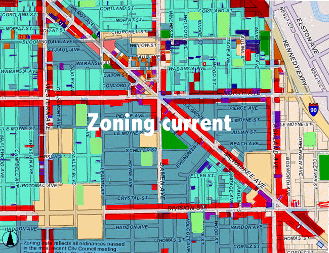
I apologize for my efforts on the current zoning map. Decades of spot zoning have left it looking like a painter’s drop cloth. There are so many, that I gave up East of Ashland.

Paul K. Dickman


Sunday, August 9, 2015

Make no little plans 3, If at first you don't succeed, try, try...


Streets

It is important to realize that all the things we consider as the very model of a modern urbanist plan, things like increased transit infrastructure, increased density near transit stations and employment centers and walkable neighborhoods, were the cornerstones of these earlier plans as well.

The difference was that they wanted to reinvent the neighborhood.

To the plan commission, each neighborhood was an area bounded by four major (1/2 mile) streets. Each neighborhood would have sufficient grade schools for its intended population located on the interior with a park connecting them and perhaps a neighborhood shopping center (strip mall) on the edge.

Several neighborhoods would form a community area. Each community area would contain sufficient high schools and a large community shopping center at their junction.

Several communities would be bounded by the new expressways. Ours included not just the Kennedy, but ones on California and Grand Aves as well.

In the neighborhoods, through traffic was the nemesis of walkability. They planned to widen the major streets to provide traffic capacity, and interrupt the flow through the side streets with cul-de-sacs and loops. They also felt that alleys were a waste of land and, that  the rights of way of the side streets could be reduced from a typical 66 feet down to 50 feet.

This is what they saw a model for the new neighborhood. This one was an example they found in Columbus, Ohio.

Using this as a model this is what Wicker Park could look like.


The parks and shopping centers are taken from the actual plans, but more on land use in a later segment.

Their plan for the major streets varied widely.  In ‘42s plan for residential land and ‘48s preliminary comprehensive plan they were not specific, although it is a safe bet that they hoped to widen North Avenue to match the portion west of Western. But in 1952. their plan for the northwest central area, went out on a limb.

They wanted North ave (currently 100’ west of Western, 66’ east) widened to 200 feet (incorporating the Humboldt Park Elevated ROW). Milwaukee should be widened to 250 feet (currently 66’) at least as far south as Grand. And they felt that it would be cheaper to acquire the necessary land on streets like Damen and Racine than on Western and Ashland, so Damen, Racine, Chicago and Armitage should be widened to 200 feet.

The extra width of North and Milwaukee was to provide space to bury the rest of the Elevated lines. It was cheaper to put them in a trench and that was their plan.

By 1958, they softened somewhat. A few things had happened. For one the Humboldt Park El line closed about the time of their last plan. Another thing that happened is that the area fought for and succeeded in getting the “East Humboldt” area classified as a conservation area. This curtailed widespread land clearance and increased certain forms of federal funding for building improvement and FHA mortgages.

In a preliminary traffic study CDoT greatly reduced their road widening goals.

Milwaukee was to remain at 66’, North, Chicago and Damen widened to 100’ and Armitage widened to 80. They also seem to have given up on the Grand Ave Expressway, it was now recommended to be widened to 100’.


Milwaukee, however was not immune from further planning. In 1968 they wanted to deemphasize the diagonal streets. They presented three possibilities for Milwaukee between North and Division. All of them involved closing it to through traffic. One was to tear out all the commercial and make it a residential street, another to keep it a commercial strip, with residential infill replacing the deteriorated structures, and finally to tear out everything, build shopping malls at either end and turn the rest into a park.

The thing that surprised me the most, while researching these plans, was the disdain the urban renewal planners held for the street grid. They seemed to be of the opinion that the middle class was being driven from the city by the unrelenting monotony of parallel streets.

Paul K, Dickman


http://wickerblather.blogspot.com/2015/09/make-no-small-plans-5-we-dont-want.html
http://wickerblather.blogspot.com/2015/08/make-no-little-plans-4-if-at-first-you.html

http://wickerblather.blogspot.com/2015/08/make-no-little-plans-2-if-at-first-you.html
http://wickerblather.blogspot.com/2015/07/make-no-little-plans.html

Saturday, August 1, 2015

Make no little plans 2, If at first you don't succeed....


Blight

Alas, the tiny hamlet of Wicker Park could not avoid the planners. The city drew up a plan for us, In fact they drew up at least five official ones. An assortment of private parties drew up their own. Some, were written as a rebuttal to the Plan commission’s ideas, others came from well meaning busybodies and graduate students.

A 1939 WPA sponsored survey of housing had noticed us and its report led the city planners to label us as “Nearly blighted” in the 1942 “Master plan of residential land use”
Below is their assessment of the conditions.


Their assessment probably wasn’t far from the truth. We hadn’t been a fashionable neighborhood since the teens the housing stock was old and run down and packed chock full of people. But this war time, and although refining their plan, the city didn’t go any further.

In 1952 they drew up  "A plan to guide redevelopment in the northwest central area of Chicago" and once again they assessed our blight.

 
Add caption

You can see, the map has changed some. They separated the industrial areas (this plan had provisions for industry), the blight has moved around some, and the conservation area is much smaller. They claim the source of the data is the same 1939 survey, so I am not sure how the blight could wax and wane. Perhaps blight is in the eye of the beholder.

The city had more urgent blight to fry in Lincoln Park and Noble Sq, so it wasn’t until the late 60s that they thought about sending the dozers our way.

In 1969 they drew the “Proposed treatment areas for the East Humboldt Park, Near Northwest Area”, and once again tiny Wicker Park was on the map.


In the end, little of their plans would be built and large scale demolition would be held to a few city blocks.


Next time I’ll discuss the multiple plans for Wicker Park’s streets.


Sunday, July 26, 2015

Make no little plans


In the 1950 census, Chicago hit its peak population 3.6 million. Few realize that this last spurt of growth was due entirely to the great migration. The African American population increased 220,000 while the white population actually declined by about 3000. 

Ok, 3000 doesn’t seem like much, but when you factor in the rate of natural increase (birth rate – death rate) it constitutes a loss of 750,000 potential Chicagoans.

The first thought is to put this loss down to “white flight”, but that doesn’t hold water.


 Here’s a map. It shows areas of population loss and gain between 1940 and 1950. 
The red portions show the African American communities traced from a 1950 settlement map showing Chicago’s various ethnic communities.


Vast losses occurred in tracts where the residents never saw a black man.


The areas of loss have more in common with this map, showing areas of blight.


 Or this one indicating areas of high population density.


The city had been bleeding population to the suburbs for decades. The city of 1950 was a dump. The free market had favored the slumlord since the depression and our neighborhoods were dirty, crowded, smelly, run down places. As soon as the streetcars crossed the city limits, people loaded up their families and moved.

This didn’t escape the notice of the people who drew those maps. They are from the Chicago Plan Commission’s 1942 Master plan for residential land use.

Their plan was to bulldoze the blighted and near blighted areas, and create mini suburbs between the half mile streets, each with its own school and park. The side streets would be cul-de-sacs and the 1/2 miles widened to carry all the traffic. Then, they’d plop shopping centers at the corners.

Here’s their plan for Little Italy.


They write:
WEST SIDE REDEVELOPMENT PLAN. It is possible to create new neighborhoods and better residential patterns near the center of Chicago without scrapping all of the streets and utilities which exist today. This plan for the reconstruction of a West Side Blighted area calls for the demolition of the present obsolete buildings in order to provide much-needed open space for parks around the schools and community centers and ample yards about the residential buildings. Unnecessary streets would be closed to protect the residential sections from traffic hazards, but major through streets of the present would be retained. Heavy traffic would be confined to the super-highways and section-line streets which form the boundaries of this community. Organization of shopping facilities into coordinated centers with parking facilities and access to highways would make them easily available without conflicting with purely residential areas. Residential areas would be built up with apartment buildings three to four-stories in height and with two-story group houses. A moderately high population density would be achieved without crowding of either land or people.

Unencumbered by existing utilities in undeveloped areas, they hope to do away with the grid all together.
Here’s their idea for Scottsdale


They write:
PROPOSED PLAN FOR DEVELOPMENT OF A VACANT AREA IN SOUTHWEST CHICAGO. Here is indicated how an area of now-vacant land comprising over one and one-half square miles on the southwest edge of the city might be subdivided according to the best principles of community design. Curved streets in the interior residential portions discourage dangerous through traffic which is channelized into the bordering super-highways. Schools placed near the centers of the five neighborhoods are so located that small children can reach them without having to cross major traffic arteries. A centrally located high school with an associated athletic field and community park serves the entire community. Adjoining these facilities is a large community shopping center, and smaller neighborhood shopping centers are placed to serve two or more adjoining neighborhoods. The residential areas are separated into sections of apartments, group houses, and single-family dwellings arranged to give each type the maximum advantages of light, air, and open space around the structures. Such a community design illustrates what might be accomplished by creating an integrated community pattern designed to offer the maximum advantages for living.


Apparently the city of the future would look like Elk Grove Village.


Paul K. Dickman
These maps are courtesy of the Hathitrust Digital library, they were digitized by Google from originals in the 

Monday, May 25, 2015

The sky is falling


A couple of months ago, a blogger by the name of Hertz wrote a piece about Unecessary population loss in Lincoln Park. It got picked up by Crain's and splattered all over the web faster than cat pictures.
You can read it here:

http://www.chicagobusiness.com/article/20150323/OPINION/150329972/who-would-have-guessed-that-lincoln-park-was-seeing-population-loss
or here
http://danielkayhertz.com/2015/03/16/unnecessary-population-loss-on-the-north-side-is-a-problem-for-the-whole-city/

Ordinarily I have better things to do than debunk every blowhard on the internet, but now I have developers spouting it like chapter and verse and I want to go on the record as saying "this is unadulturated BS."

He noticed a slight decline in both the population and the housing unit count for the Lincoln Park community area between the 2000 and 2010 censuses. Rather than look closer at these numbers, he took it as proof of his thesis that zoning is killing the city and now McMansionization sucking up precious dwelling units. Then he ran around like Chicken Little yelling "the sky is falling"

How big were these losses, he didn't say, but the population loss amounted to 204 people (0.3% of the pop)
Given that the city on average lost 6.9% of it's population in the same period, I'd say that's pretty darn good.

http://www.cityofchicago.org/content/dam/city/depts/zlup/Zoning_Main_Page/Publications/Census_2010_Community_Area_Profiles/Census_2010_and_2000_CA_Populations.pdf

The housing loss was a whopping 534 units. But when you drill down to the actual data, the bulk of this loss (over 400 units) occurred in 3 census tracts dominated by the DePaul campus who started expanding and restructuring their planned development just before 2010. Hardly gentrification and more than adequately compensated by this project:
http://www.usa.com/IL0318325002001.html

Smithfield's 1237 West Dorm project. It came on line before the census and is so big it has it's own census block. It housed 481 people, but through the vagaries of census definition it only constitutes 5 housing units.

Here's a chart to illustrate the situation.
The red area indicates LP's unit count, the blue area LP's pop and the green area the city's pop (divided by 40 to bring it into scale)

Hardly the end of the world.

Certainly gentrification has consumed some units but it is a drop in the bucket and not necessarily a bad thing.
Lincoln Park is approaching the Units/mile it was designed for and now it's time to grow up. It's problem is not its unit count but its puny household size of 1.73. It's time to start procreating, maybe then they achieve a higher population density than Albany Park, a mature RS-3 district which, despite a population decline of over 10%, still manages a density 35% higher than Lincoln Park (which for the most part is zoned for densities 3 to 7 times as high).

The article also pines for the glory days of the 1950s but the author seems oblivious to the fact that in the fifties, Lincoln Park was a frickin slum. I imagine he pictures the fifties as all "Leave it to Beaver" and "Happy Days" but it wasn't, it was more like "Blackboard Jungle"
It would never have become a fashionable neighborhood until the Dept of Urban Renewal bulldozed half of it down.
Lets look at one census tract from the 1950 Census of housing.

It had 2447 DUs (it would be more now, until 1960 SROs, Residential Hotels and Rooming houses were each one DU)
300 of them had no heat
10% still used ice boxes and 5% had no refrigeration.
747 had no washroom, 337 had no running water at all.
Those were the days.
By 1970 it was down to 1700 DUs 20% of those were vacant.
You'll be happy to know that they all got running water. But 10 still used an outhouse
In 2010 it was down to 1477 DUs.
The good news is that the median rent went from $20 to $2000.

There is some kind of fantasy that Joseph and Mary are on the west side of Harlem waiting to live in Chicago but there is no room in the inn.
This notion that "if you build it they will come" is a fallacy
In reality we have about 99% of the DUs we had our peak in 1960 and the difference in household size doesn't explain the difference in population.

Except in Lincoln Park. If they got their Household size up to the current Chicago average they would have over 90,000 people living there.

You young people should be humpin' like bunnies. I don't know what the problem is, maybe you should try some candles or scented oils.

Paul K. Dickman


A kindred post for further reading
http://yochicago.com/crains-deeply-misleading-article-on-lincoln-parks-population/38674/

Saturday, May 23, 2015

No highway in the sky

You know, I can't go to a meeting, or even have a discussion, about the Bloomingdale trail (AKA The 606) without someone asking the question, "When will they extend it to the river?".

I'm here to tell ya, quit askin'.

The answer to that question is "Not in our life times."

The people building it won't tell you that. When asked, they hem and haw around it like a politician being asked about taxes.
I'm not sure why they do that. One guess is that a lot of money for alternative transportation is backing the construction and they don't want to admit that it is the bicycle version of the Amstutz Highway (AKA The road to nowhere) until they finish this part.

The problem is that on the other side of Ashland the ROW makes a grade crossing with a commuter railway. In fact with two lines of the Metra UP. On the average week day, during park hours, over 130 trains cross there. About 1 train crossing every 8 minutes. A crossing gate isn't an option.

How about a bridge? To build a bridge to clear the bi-level rail cars to ADA standards (slope of 1 in 12 and landings every 30" in rise) will require ramps around 250 feet long. The good news is that there is enough land there to do that and connect to another underused track that crosses over Clybourn and runs directly to the river.

The bad news is that they don't have the headroom.

The expressway crosses over the Bloomingdale line about 60 feet from the Metra tracks. In fact the height of the expressway bridge at this point was designed specifically to to clear the loading guage of a boxcar on the Bloomingdale line. I estimate it to be no more than 20 feet above the railbed. But that doesn't matter, the trail bridge would need at least as much structure gauge to clear the commuter line 60 feet away.

60 feet, one landing. You will have a maximum of 57 inches of headroom when you pass under the Kennedy.

You could build a bridge that rises 10 feet under the expressway, turns 90 deg, goes another 125 feet, turns 90 deg again over the tracks and does it all over on the other side. This is a lot more complicated and involves rights of way they do not own.

In some ways, a viaduct would be a better solution. It only needs to be eight or ten feet deep. That would still be above the street level so drainage would be easy.  But you would need a bridge to support the rails. I can't imagine that happening without interrupting all rail traffic on those lines for at least a couple of weeks, Not bloody likely.

Getting the trail to the east side of the Metra tracks will probably cost more than all the other bridgework on the trail, and CDoT won't be doing much of it. Until a river trail runs all the way downtown, the impetus to fund such an undertaking will not exist.

Accept the 606 for what it is. A nice park, someplace to take a stroll on a sunny morning and maybe a bicycle shortcut from the "K" streets to the Metra station. But it's no highway in the sky.

Paul K. Dickman

Sunday, May 10, 2015

Bicycle Birtherism

In Jan of 2014, The Tax Foundation published this study that showed that user fees on cars only paid 51% of road construction costs.
http://taxfoundation.org/article/gasoline-taxes-and-user-fees-pay-only-half-state-local-road-spending

This was bandied all over the Internet by the usual suspects as proof that auto-mobiles are a losing proposition and that non-drivers property taxes are subsidizing the drivers' lifestyle.

For what it's worth the original study was true, but they construed user fees pretty narrowly (MFT, tolls, licenses). That is like saying that the news stand price doesn't cover the cost of publishing magazines. Everyone knows that, like roads, other revenues makes up the bulk of their income.

In fact, the Tax foundation's previous study showed that cars only covered 1/3 of road costs because the felt that licenses and the Federal Motor Fuel Tax were not dispersed proportionately and shouldn't be called user fees.
http://taxfoundation.org/article/gasoline-taxes-and-tolls-pay-only-third-state-local-road-spending

A more in depth study from 2007  looked at a much wider range of revenue sources like sales taxes, fines and income taxes and corporate taxes from the auto and gasoline industries, and even this study showed that income and expenses were pretty close to even until you started adding intangible expenses like the wars in the Middle East.
http://ti.org/delucchiinpress.pdf

That may be how it plays in Peoria, but I'm here to tell you that's not the Chicago way.

Here in the Windy City, the auto-mobile is a major cash cow and my bona fides are as close as the city's 2015 budget.
http://chicityclerk.com/wp-content/uploads/2014/10/2015OV.pdf

I didn't try to track the path of the MFT or the City sticker revenues to their final destinations. That would be a fools errand, and frankly I don't care how the Department of Buildings justifies 6 full time employees being funded by the Illinois motor fuel tax. My approach was simply X amount of income comes from auto-mobile related sources and Y amount is spent on maintaining the roadway.

Income sources include, State, Federal and Municipal Fuel taxes, City sticker revenues, impound fees, Fines for parking and red light/speed camera infractions and a variety of taxes on taxis, parking lots, etc,. I ignored less verifiable sources like sales taxes on gasoline and cars, and property taxes on gas stations and parking lots.

Expenses are simply the gross budgets of CDoT and Streets and San, including infrastructure and administrative costs, minus trash pickup, rat abatement and those infrastructure projects solely for pedestrian, transit or bicycling. Certainly there are other costs, like fire and police calls related to autos, but these departments benefit from the roadway as well. The Fire Dept's budget would be a lot different if they had to limit each stations range to a distance they could transport their equipment on a rickshaw. A few years ago, (to double check a private traffic study), I took a series of rush hour traffic counts on North Ave. An unexpected observation was that 10% of all vehicles and 25% of all heavy vehicles, belonged to the city. Buses, garbage trucks, police cars, Water Dept dump trucks all depend on the pavement to do their job.

But enough of that, Here are the numbers.

Expenses:

+$258,865,234   Streets and San Total budget
- $156,645,516   Less Solid waste (but including street sweeping)
+$598,286,287   CDoT Total budget
 -$206,643,000   Less Bike, Transit, Pedestrian improvements

  $493,863,005  Total Auto spending


Income:
    $99,100,000 State MFT
  $205,100,000 Vehicle tax(Sticker, towing, impound)
  $188,000,000 Transportation taxes (City MFT, Garage, Taxi)
      $6,400,000 Motor Vehicle Lessor Tax
     $4,100,000 Municipal auto rental tax
     $6,400,000 Municipal Parking
  $256,000,000 Fines, Forfeitures, Penalties (auto related)
  $298,800,000 Infrastructure Grants (sourced from Fed or State MFT)

$1,063,900,000 Total Income

$570,037,000 Profit

Just for perspective, top income sources listed in the Budget are:
$1,299,000,000 Airports
$1,150,400,000 Water and Sewer
  $831,500,000 Property Tax Levy

So, the gross revenues collected, make the auto-mobile Chicago's 3rd highest income generator and the profits are on par with the $647,900,000  the city hopes to receive from its share of the State and local Sales taxes.

Paul K. Dickman