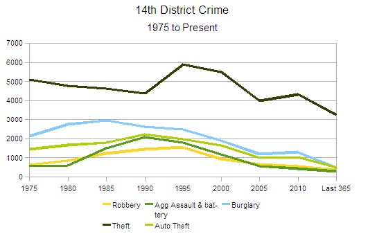
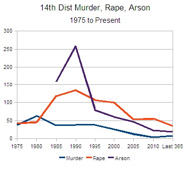
Monday, January 9, 2017

Bucktown, Neighborhood on The Make

Of course, everybody has heard of Bucktown. That's where the canaries bark at bulldogs, little girls in kindergarten sing bass and their pappy shaves with a blowtorch. Some of society's blue bloods still remember when their ancestors crossed the Chicago river from Goose Island and started to pioneer Bucktown.
Throwing things seem an inherent trait among Bucktown's citizens. Stroll through any alley any time and you will observe some housewife heaving a can of gooey garbage from the third story back porch. If the garbage goes over the fence into the alley, the kids drive another spike into the kitchen wall plaster to record the bull's eye.
The southern boundary of Bucktown is a large automobile parking lot called Armitage Avenue, where all the reliefers park their cars.

John Fisher Letter to Chgo Tribune Nov 1940

To be fair, Mr. Fisher didn't live in Bucktown, according to the census he lived on the west side of Western in what some now call West Bucktown.

This was only the second mention of Bucktown in the press. The first was in 1898, about the price of bread, but that was a different Bucktown. 

The original Bucktown was what we would now call Noble Square. It's that Bucktown that Mrs. Henry Hartjen opines on in 1953 when recalling her childhood days around Noble and Division Sts. Our neighborhood was near a place called Bucktown”.


It's that Bucktown that Nelson Algren refers to in 1947's Never Come Morning, when he says Lefty “looks a good deal like all the other young toughs around Bucktown”


It's that Bucktown that a machinist and putter maker in Schiller Park named Louis Malik talked about in 1969 when he says he came from the old Bucktown area of Chicago, around Milwaukee and Augusta.


And it's probably that Bucktown that the story about the residents keeping dairy goats comes from.

The area around Armitage wasn't called Bucktown until the 1920's. My mother lived above her father's (Vincent Bielanski) bakery at 2059 N. Oakley at that time. To her, Bucktown's boundaries were Damen, Western, Armitage and Fullerton. She also thought the dairy goat thing was the funniest thing she ever heard. “Milk was cheap as dirt” she said, “the only goats around there were in back of Roman Bruszkiewicz's butcher shop, next to St. Hedwig's.” She used to play with them when she went over there to trade bread and kolacz for smoked sausage.

These boundaries remained the same for the next fifty years.

In October of '76 the Trib writes:

In May of '79 it reiterates:


So when did it start to expand?

 In the summer of 1971 a group of citizens formerly called the St Hedwig's-Pulaski Community Organization met at Holstein Park and renamed themselves the Triangle Community Organization. This was the forerunner of the Bucktown Community Organization. At this stage Bucktown was just part of the area they represented. It wasn't until 1983 that the notion of branding the larger area as Bucktown crossed their minds.

In 1983 they published a pamphlet called “The Triangle Community Organization welcomes you to Bucktown” in which they declare, 

Bucktown is three miles northwest of Chicago's Loop. Between Fullerton, Armitage, the Kennedy Expressway and Western...”


They even included this convenient map.

This branding paid off. The name was picked up by realtors looking for someplace to hawk and it was soon applied to every thing down to the Milwaukee road tracks at Bloomingdale

Bucktown, went from a place never advertised before 1978 to the hot neighborhood DuJour.


But still, Bucktown never crossed the Logan Square/West Town divide. 

But in 1988 a real estate developer by the name of Ron Gan bought a tract of land at Wabansia and Paulina from the Archdiocese. It had been the Church of the Annunciation and its school. At one time it was the Irish church in the neighborhood but it had been closed for a decade.

Ben Joravsky interviewed Gan for a Reader article that year. Ben writes: 

Gan is the creative type. He's an exuberant optimist, a master salesman. You say the land is actually in West Town; he says, well, boundaries are subjective, and at the very least it's close to Bucktown--which he believes has a more upscale ring to it.” 

That was the day Bucktown crossed the Logan Square/West Town divide. At least as far as the realtors were concerned. 

But back then, even the Bucktown Community Organization wasn't buying it. Their own web page said: 

the Bucktown area is bounded roughly by Fullerton on the north, on the east by the Kennedy Expressway, the Milwaukee Road railroad tracks on the south, and on the west by Milwaukee Avenue to Western, and Western north to Fullerton.“ 

At least until 2010 when in a fit of expansionism they rewrote history and changed it to: 

“the Bucktown area is bounded roughly by Fullerton on the north, on the east by the Chicago River, North Ave. to the south, and on the west by Western." 

And started hanging Bucktown signs south of the Logan Square border.

Why did they do this?

Who knows. Maybe they have dreams of manifest destiny. Perhaps their own lackluster commercial areas on Armitage and on Milwaukee north of Bloomingdale were proving to be an embarrassment.


But, If I was Noble Square, I'd keep my back gate locked.

Paul K. Dickman

Friday, June 17, 2016

Crime Wave 2

'I was gonna leave it alone after putting up the 1976 crime stats in We're havin' a crime wave.
 But a couple of barflies got into it on Milwaukee Avenue and one of 'em got stuck. Now everyone is moaning about how Wicker Park used to be a safe neighborhood and upticks in crime.

Wicker Park was never a safe neighborhood. No neighborhood in the city is.    (except perhaps Edison Park)
Wicker Park is the safest it's been in over 40 years.

Here are the index crime stats for the 14th district.


I feel sorry for cops at Caps meetings. They sit there while people rant and rave, but I know that the only thought going through he cops heads is,

"Jeez, white people's problems"

That's not to say everything is rosy. We do have a crime wave of sorts.
30% of all our index crime consists of someone getting shit stolen out of their car.

Wanna take a bite out of crime? Never leave anything more valuable than an empty cheeseburger wrapper in your car.


Paul K. Dickman


Tuesday, June 14, 2016

We're havin' a crime wave

Back in the late 70s, some sociologists at Northwestern got a Dept of Justice grant for something called the "Reactions to crime project". They went to urban neighborhoods and interviewed the locals about local crime and compared this information to the actual local crime statistics. One of the Chicago neighborhoods was Wicker Park (along with Lincoln Park, Woodlawn and Back of the Yards.)

Today I want to highlight this:
This is the annual crime count for 1976 crimes in Wicker Park. (Augusta to Armitage, Western to Ashland)

Look at those counts. They were 6-10 times higher than they are currently. They're higher than the entirety of West Town. In fact I would put them up against any similar sized area in the roughest parts of Englewood or Austin and make those neighborhoods look like Mayberry.

In any event the original studies can be found here:
http://skogan.org/files/Lewis_and_Maxfield.Fear_in_the_Neighborhoods_An_Investigation_of_the_Impact_of_Crime.1980.pdf
https://www.ncjrs.gov/pdffiles1/nij/85917.pdf
https://www.ncjrs.gov/pdffiles1/nij/85506.pdf
They're required reading for any student of Wicker Park history.Particularly the second "The methodological overview" it contains some great contemporary accounts of what the neighborhood was like when it started to gentrify.

Paul K. Dickman

Saturday, April 30, 2016

Men Are Like Streetcars

You've all heard the old saw,
Men are like streetcars, another one will be along any minute.
I never gave it much thought until I ran across this while researching urban renewal efforts in the Wicker Park area. It's a report of transit service from 1951's "A plan to guide redevelopment in the northwest central area of Chicago" by the Plan Commission and is courtesy of the Hathi Trust digital library.


Take a look at the Milwaukee Streetcar. In each direction it ran, on average. every 2 1/2 minutes and every 58 seconds during rush hours.

Imagine the convenience of stepping out on the street and having transit show up in the time it takes you to get the change out of your pocket.
Imagine a transfer. How much time do you add to your schedule when ever you have to change buses?

When the CTA took over the transit system, they ushered in an era of efficiency. Don't get me wrong, at the time it was what saved mass transportation in Chicago. But the philosophy of maximizing each bus load a the expense of customer convenience is still in effect to this day.

If you want more people to chose transit over their own auto, you have to make it so convenient that driving is a waste of time.

It doesn't do much good to shave 8 minutes off a 16 mile bus ride if I have to waste half an hour waiting for a bus.

Paul K. Dickman

Monday, December 14, 2015

They won't let their beloved neighborhood become another Wicker Park,

A recent article about anti-gentrification forces in Pilsen contained the this statement.

As a Wicker Parker, I freely admit that we chose the path of gentrification, but I am tired of being the poster child for a narrative about people being displaced by Yuppies and Hipsters.

This narrative is usually accompanied by a graph like this.


It seem to show that Hispanics, after being displaced from Lincoln Park in the 60s, migrated to Wicker Park. Which grew to a predominantly Latino neighborhood, only to have them displaced again by Yuppies in the 90s.


Technically it is true (except for the part about growing) but it doesn't tell the whole story.

I have spent a lot of time pouring over census records of the 8 tracts that make up Wicker Park and here's a chart of its Hispanic population count.


You'll notice that the numbers jump in 1970 and have declined ever since.
There is no precipitous drop in the 90s. In fact the decline is so close to a straight line that no evidence of any period of displacement can be found.

Back then, Wicker Park was a slum. It was that way already in the 1960s and it was apparent to the incoming Hispanic population. No sooner did they get here, than they started to leave.

Here's a chart comparing the change in each group's populations between each census.


The period of Hispanic dominance of the population came not from the growth of that group, they were actually declining in numbers. Instead it came from the fact that everyone else was leaving faster.

That ratio switched in the 1980s.

Paul K. Dickman

Tuesday, September 8, 2015

Make no little plans 6, Unintended consequences


Two flats

A curious thing about the 1957 zoning code is that it pretty much made it impossible to build a two flat on a standard city lot. I have always wondered about it. I’ve never heard anyone complain about them. The previous code had duplex districts where such things were a matter of right. The 57 map  replaced them with R3 districts. But the text precluded putting a two dwelling structure on one lot in those districts.

The standard city lot is 25x 125 to 25x150 or 3125 to 3500 square feet.

The Code controlled density by limiting the number of dwelling units by the square footage of the lot.

In the case of R3 it was 2200 sq ft of lot area per dwelling unit. As you can see, in order to build a two flat you would have to combine two standard lots. Why would you bother? Why not just build two single family homes?

The new code also defined the minimum lot size for each district. I have always wondered about this as well, I mean the city was 95% subdivided by 1957. Why would anyone think it was an issue?

As I researched these articles, I could find no enmity to this humble dwelling. In fact I found quite the opposite. The Master plan of residential land use of Chicago clearly stated that they expected 25%-35% of the city’s population to reside in “Two family dwellings”.

Why were these excluded from the 1957 code? Was this just some typo that followed us to this day?

Then I read “Building new Neighborhoods; subdivision design and standards, 1943”.

And it became clear. 
They intended to change the size of the standard city lot. 
Actually, they hoped to re-plat the bulk of the city
In their opinion 25 ft lots were too narrow, 35 ft was marginal, 40-50 ft was preferred.

A 35x150 lot has 5250 sqft more than enough for two dwellings.

“How’s that supposed to work.? Wouldn’t a 35ft lot line be in the middle of someone else’s house?” you might ask.

Not if you tear them all down.

They write:
REDEVELOPMENT OF OLD CHICAGO
The recommendations contained herein pertaining to subdivision design and standards would apply not only to the land now vacant but to the redevelopment of the 23 square miles of blighted and near-blighted properties which must be rebuilt within the next generation. Thus more than 41 square miles of land in the city would benefit from improved standards of design and from practical specifications for residential land improvements. Within these 41 square miles over 300,000 families could find new home sites located in well-designed, attractive neighborhoods of good character and environment.”

Still, that’s only 20% of the city.

In the Master Plan they defined the areas of the city as:

14.60% Blighted & Near blighted
36.31% Conservation
23.34% Stable
the remainder was either vacant or under going some kind of development

You can see them in this map.

Notice that the only areas they have marked as “Stable” are out in the “Bungalow Belt” where the lots are already wide.

They figured that by the time they dealt with the blight, the “Conservation” areas would now be blighted, either through decay or by contrast with the “Rebuilt” areas. And then they would redevelop those.


Here’s another map of future development areas.

Notice that the areas formerly tagged as “Conservation” are now labeled “Ripe for rebuilding”

And the former “Stable” areas, now they’re tagged as “Conservation”.


Since the future solvency and livability of our great cities depend upon removing the cancerous blighted areas that are sapping their vitality and upon building new model communities on the cleared sites, every device, legal and financial, should be employed to make it economically feasible for the blighted areas to be rebuilt by private enterprise.


The scope of this is staggering. They fully intended that the normal process of future development, would involve taking property through eminent domain, clearing it at government expense and redistributing it to some connected developer who build only what the Plan Commission liked.

Luckily, this did not come to pass, but as casualty of battle, the two flat was lost.
It needn’t be permanent though. You need only change one character of the current zoning code to make these “as of right” in RS3 districts.
Change the Minimum Lot Area per Unit Standard for RS3 from 2500 to 1500.

This would double the population density potential of about half the city and hopefully spur development out in the neighborhoods where it’s needed.

These maps are courtesy of the Hathitrust Digital library, they were digitized by Google from originals in the 
University of Michigan collection

Sunday, September 6, 2015

Make no little plans 5, We don't want nobody nobody sent


Wicker Park’s first renewal project would also be part of its last, although the two would be separated by almost 30 years. In ‘55 and ‘56 they demolished a couple of dozen homes on Mautene and Bauwans (two streets now almost completely lost to history) to make way for some parking lots where they planned to put the new shopping center.


This was noticed by some in the community and in’56 the East Humboldt Park Planning and Conservation Commission was formed with the intent of getting the area designated as a “Conservation District” The Illinois Urban Community Conservation Act of 1953 and it’s clone, the Federal Housing Act of 1954 created these districts to allow urban renewal in areas not yet classified as slums. It freed up federal money for land acquisition as well as for repairs to existing structures. For the city however, it would have one fatal flaw, it required community input.

The East Humboldt commission was headed by Valentine Janicki, a local business leader, owner of the United Novelty Mfg Co. and future president of the Polish Alma Mater Association. He was not without his own agenda. He had his eye on 9 sq blocks of land his commission felt need to be cleared. He also had political aspirations, after this he would parlay his Polish and political connections into a seat on the sanitary district, where like all good Chicago politicos he would eventually be jailed in a sludge hauling kickback scheme.

In ’57 Mayor Richard J. Daley, conscious of the Polish vote appointed him to the Community Conservation Board, the group that selected which parts of the city would become conservation areas and in ’58 East Humboldt Park, an area bounded by Grand, Fullerton, California, and the river (later the expressway) would gain that distinction.

Without Janicki at the helm, the East Humboldt commission drifted into obscurity. This was probably a good thing. The Community Conservation Act was literally designed to be co-opted by private enterprise. It was created to allow the University of Chicago turn Hyde Park into their personal compound and later was used by the Southtown Planning Association in their goal of stemming black migration in Englewood.

The city started making a conservation plan but was playing it close to the vest. Its next two clearance projects were several houses on Damen for rebuilding the Wicker Park School (now Pritzker) in 1960,

And a large parcel just to the north of this for the CHA elderly high rise project at Damen and Schiller in 62 -63


These, and announcement of several clearance projects, including the one in what we now call Noble Square, would be a wake up call. Several church leaders, fearing the dispersal of their flock in 1962 formed the Northwest Community Organization (NCO), a supergroup of smaller community organizations and a member of Saul Alinsky’s Industrial Areas Foundation. The local community group at the time, The Wicker Park Neighborhood Council aligned themselves with the NCO.

The NCO managed to get several sympathetic people appointed to the  East Humboldt Park/Near Northwest conservation area’s Conservation Community Council (CCC),  a Mayorally selected body of local citizens with oversight and veto power over the plans and recommendations of the Dept of Urban Renewal for each conservation area. Together they would battle the city to a halt at every turn.

In ’67 they battled the plans for the Tuley High (now DeDiego) expansion. Although they wanted its expansion, the Board of Ed and the DUR wanted it to go east across Clairmont to Oakley in the land they preemptively downzoned for a park. The NCO felt the properties to the west were in much worse condition and better candidates for demolition.

In ’68 the NCO would convince the Board of Ed to build a new high school inside Humboldt Park, but that would backfire. They would have to swap land to the park department. You guessed it, the land they wanted to swap was the same blocks, Oakley to Leavitt, Potomac to Hirsch they had downzoned. So the NCO fought that too. In the end the city built Clemente on the site of an old street car barn.
 
In ’69 the city produced its conservation plan for the area, a vague document with large areas slated for demolition and the NCO went apesh!t. They wrote their own plan. the “People’s Plan” It called for only spot removal of dilapidated buildings, no new construction over 3 stories and, the dealbreaker, 90% of all new construction to be affordable housing.
Through their seats on the CCC they vetoed any plan that didn’t conform to theirs.
Daley, tired of this stalemate, tried to break their power by appointing five of his own people to the CCC in place of theirs, and the NCO took him to court. They won and the city pretty much threw up its hands. 1973’s Chicago 21 plan did not include anything west of Ashland.

Despite this victory NCO would play a roll in the extensive loss of Wicker Park’s housing. Between 1970 and 1980 we would lose 22% of all our housing units. But few would be at the hands of the city, most were due to arson.

Two initiatives combined in ways no one could foresee.
The NCO used the Department of Buildings to put a lot of pressure on absentee landlords, calling in inspections constantly, in some cases forcing demolition but mostly to force landlords to repair them.
Most of Wicker Park was redlined by the banks until the early 80s, mortgages and home improvement loans were simply unavailable. But what most people don’t realize is that we were redlined by insurance companies as well.

The NCO struggled to end the redlining. They had succeeded to get the FHA to back some mortgages, but the FHA was only interested in single family properties. They also lobbied for a high risk insurance pool. After the King riots, they got their wish. The Fair Plan Insurance Act made it possible for anyone to get affordable fire insurance.

Faced with a low rent property, more valuable as a vacant lot, with the city saying, repair it or they would condemn and take it, the availability of fire insurance led to the biggest epidemic of landlord lightning in the city’s history.

Evergreen between Leavitt and Hoyne lost 2/3 of its buildings and looked like a war zone.

Although the pressure from the DUR was off, Wicker Park was still in trouble.
Housing losses continued. Between 1970 and 1980 we lost 35% of our population and the neighborhood became a house divided. Gang struggles, ethnic tensions, all played a role, but for our story the biggest divide was between those who thought that rising property values were a bad thing and those who thought it was good.

Those people, labeled gentrifiers (probably rightly) had an idea, landmarking. It could stem the housing loss and get federal grants (in the early years) for repairs. They formed the Old Wicker Park Committee to lobby for this designation.  In 1979 they succeeded in getting it much of it designated a National Historic Landmark District and set about to actively promote the neighborhood.

But battle lines were drawn in the neighborhood, one group protested affordable housing developments, one protested market rate housing developments. One took realtors to court for putting up “For Sale” signs, the other sued over design issues of affordable housing projects. Neither group could see the goals they had in common and neither could claim this as their finest hour.

The city still had some plans up their sleeve. Determined to get one of their plans realized, in September of 1977, Richard W. Albrecht, the city's deputy project planning coordinator, and Robert Littlebridge, director of economic planning for the city's department of planning, under Bilandic, visited Sievert Electric company on Ashland and told them not to go ahead with any expansion because the city had an interest in the area.

In October of ’79 the next mayor, Jane Byrne, announced their plan for the “West Town Shopping Center”. At first it seemed to only involve the vacant Weiboldt’s building, but less than a month later it became clear that the project involved the clearance of nearly 60 buildings.
 
The first developer for the project backed out when $7 million in federal loan guarantees were denied. Perhaps it was just Reagan era austerity, but a Jan 20, 1981 memo from the U.S. Dept of Commerce said “The projected retail sales from the applicant’s project would overwhelmingly come from the current business of existing competitors. This project will have an adverse impact on existing retail and office space sales”

But this didn’t stop the project. Joseph Freed stepped in and took it over.

At the cost of approx $.25 million in 1955 dollars for the parking lots and $3.73 million in 1980s community block grant dollars, the city acquired and cleared the land and sold it to Freed for $635,000. Then they got him property tax incentives worth an additional $4.9 million.

The NCO would wage a valiant effort but they would lose. It would be their last hurrah. They continued on fighting smaller fights until 1993, when the would close up shop. Although their financial arm, the Bickerdike Redevelopment Corp would continue to this day.

The U.S Dept of Commerce’s memo would be prophetic. Unless you include the time when it was filled with government offices, I don’t think the shopping center ever replaced the 275 jobs it displaced and I doubt that it ever paid as much in taxes as the businesses and residents on the 120 parcels it contained would have. While the rest of Wicker Park’s shopping areas blossomed, the south end of Milwaukee Ave languished.

In the end, the gentrifiers would prove to be right. The housing losses declined through the 80s and turned positive in the next decade at a rate nearly 20 times the city average. We have put back all the housing we had in 1970 and after 25 straight years of population growth (25% since 1990 vs City pop -2%) we’ve put back all the people we had in 1980.

According to the 2013 estimates, the current population density is around 25,000 ppm.
If our household size matched the city average, we’d be in the mid 30s, right where they wanted us at the start.